A Hiker Trash Guide

to the Hayduke Trail
Offline topo maps, real-time water reports, GPS navigation, and community trail conditions for 800 miles across Utah's wildest canyon country.
Good starting points for planning your trip: Jupiter's guide, Halfway Anywhere, the original Hayduke guidebook, and Peaches' notes on the HDT.

Get the App

iPhone app is available now on the App Store. Android is in beta testing.

iPhone / iOS

App Store

Offline topo maps, GPS navigation, waypoints, water sources, and community trail conditions for the full 800-mile route.

Download on App Store

Requires iOS 16.4+.

Android · Beta

Google Play Testing

Android testing is through a closed Google group. Join the group first, then access the Play Store testing link to install.

Join the Google Group Play Store Beta

Step 1: join the group. Step 2: install from Play Store. Both links required. Contact [email protected] with any issues.
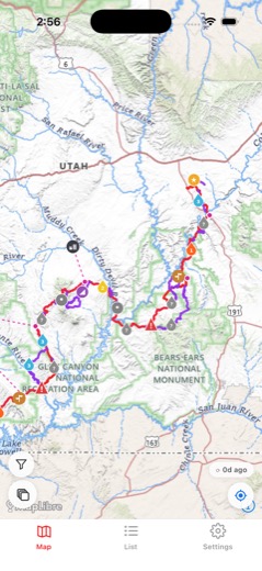
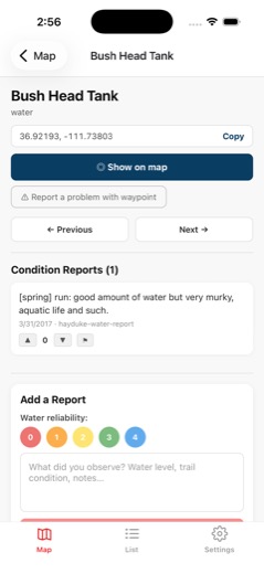
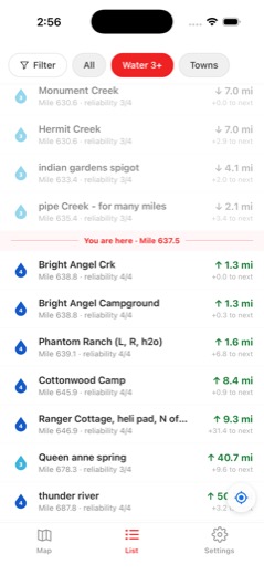
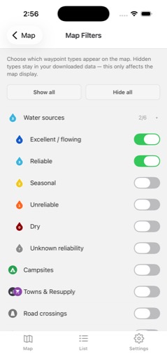
App map view App waypoint list App waypoint detail App elevation profile
~800
Trail Miles
413
Waypoints
47
Alternate Routes
226
Water Sources

Built for the Hayduke

🗺️

Offline Topo Maps

Download USGS topographic tiles for the entire trail corridor. Full GPS navigation with no cell service required.

💧

226 Water Sources

Community-sourced water conditions with reliability ratings. Know which springs are flowing before you commit to a dry stretch.

📍

413 Waypoints

Water, campsites, resupply points, road crossings, hazards, and landmarks. All pinned to the GPS track with descriptions and condition reports.

🔀

47 Alternate Routes

Official Hayduke variants, bad-weather bypasses, and high-water detours. Toggle them on the map and compare distance and gain.

📊

Elevation Profiles

Elevation gain, loss, and profile for every section and alternate. Useful for planning water carries and picking camp spots.

💬

Community Reports

Leave and read condition reports on any waypoint. Trail conditions sync automatically when you're back in service.

How It Works

1

Do your research first

Read the Jupiter Guide, study water carries, and review the community notes on trailpeaches.com/hdt before your trip. This app is your on-trail companion, and should not be your only planning document.

2

Download the app

Available on iPhone and Android. Create an account to sync your data and condition reports across devices.

3

Download trail data on WiFi

Grab the full Hayduke trail pack (maps, waypoints, water reports, alternates) before you head out. Everything works offline once downloaded.

4

Navigate on trail

GPS position on topo maps, nearest waypoint info, distance to next water, and section progress. No cell service needed.

5

Report conditions

When you hit service, your trail reports sync automatically. Help the next hiker know what's flowing and what's dry.

Explore the Trail

🗺️

Interactive Trail Map Preview

View the full Hayduke route, alternates, and waypoints in your browser.

About the Hayduke Trail

The Hayduke Trail is roughly 800 miles of canyon country in southern Utah, connecting Arches, Canyonlands, Capitol Reef, Bryce Canyon, Grand Staircase-Escalante, and Grand Canyon through some of the most remote and wild desert terrain in North America. Most of it is cross-country. It will humble you.

The trail is named for George Washington Hayduke, protagonist of Edward Abbey's The Monkey Wrench Gang (1975) and Hayduke Lives! (1990). If you haven't read them, fix that before you go. This app has no affiliation with Abbey's estate or any rights holder of his work.

The Hayduke was conceived by Mike Coronella and Joe Mitchell in the 1990s. Mike spent years testing water sources, navigating the canyon terrain, and piecing together a route that connected the parks without ever becoming a proper trail. He's talked about wanting it to stay that way -- an idea as much as a path. Whatever you think of apps and route guides, that spirit is worth keeping in mind out there.

Good Resources

Important: waypoints and tracks in this app are not authoritative navigation data. GPS coordinates, trail lines, and waypoint locations are community-sourced and may be inaccurate, incomplete, or out of date. They represent a general route corridor only, not a precise path to follow. Do not rely on this app as your sole navigation source. Always carry dedicated GPS devices or apps (e.g.Gaia) and other redundant navigation tools like a physical topographic map and a compass. Verify water sources independently before committing to dry stretches. The Hayduke crosses remote desert terrain with serious hazards including extreme heat, flash floods, and lack of emergency services. Check current conditions with the BLM and NPS before you go. No information in this app is guaranteed to be correct. Use your own judgment out there.